
BRAHEHUS
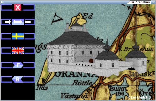
Brahehus give you a roughly hint, to the Swedish 17th century castles original appearance. Built on the edge of a 90 meter high rock face, with a splendid view over the lake Vättern downbelow. Today a ruin, with the highway (E4) passing a few meters away.
The programmes/apps exist in versions for Linux, Windows and Android. Download HERE.
BRAHE
Brahe became Swedens first countship in 1561. The county named Visingsborg. Associated to Brahehus are Per Brahe den yngre (d.y. = Junior) and his first wife Kristina Katarina Gustavsdotter Stenbock. Little seams to be known about here. She meet Per at the Swedish court, and was described as a cheerful person. Not surpricing are there a lot more to know about Per. He became colonel in the cavalry 1628. During 1630 was he active in the big war in todays Germany. After King Gustav II Adolfs death (1632), from a period in Sweden, he returned as an administrator close to Axel Oxenstierna. 1637-41 and 1648-54 was his position as generalguvernör (governor) in Finland. The city Brahestad (Raahe) have its name after him. His highest rank at home was as Riksdrots, this for a long time (1641-80). Before 1660 the title meaning judge of Svea Hovrätt (court). Later as a sort of minister of
justice for the whole country.
His position in the establishment was very important for him. But he has by the sources of his days, a good reputation. This maybe compared to the rest of the 17th century nobility. What the common people saw in him, will be harder to know.
BRAHEHUS
The real builders (craftsmen) of a place like Brahehus will most likely not be known by their names. The leader of paintwork indoors and outdoors are anyhow known, Johan Johansson Werner. The position high on a rock face, was hardly a practical place to live. It was still, told to be a residence for Kristina as a widow. Representation and propaganda must have been other key factors to build at this location. The view over lake Vättern are still stunning today, and must also have been a landmark for those who traveled down on the lake. Brahehus was completed early 1650-s. Then was Kristina already dead, so it never became a part of any widowhood. Anyhow not a practical place to live on. Especially considering the more then usual severe winters during this period. After The Great Reduction had the nobilty not much money to spend on this type of bragging anymore. This plus a fire that started down in the village Uppgränna 1708, which spread up the rock face to Brahehus, ended the business. Leaving todays ruin. Restauration- and conservation-works has been performed in steps from 1911.
For the creation of this 3D-model, are the basic structure and dimensions pretty clear, at least at ground level. Details are harder to be sure about. The copper engravings of Suecia Antiqua Et Hodierna (books), are not to be trusted. To create 3D-models takes time. And even if more details were added, no one could be sure of the correctness of them. Hopefully will this give some hints to Brahehus in the past.
CROWN VERSUS NOBILITY
Alsnö stadga was signed by King Magnus Ladulås 1280 (or close after). As a contract between the King and the Nobility, can it in some ways be seen as a Swedish Magna Charta. Among other things in this document, gave the majesty exemption from taxes to the nearest men of King and the Bishops. This also to those that could provide an armoured knight with horse, to serve under the King. A Swedish nobility had now formally been created. But the peasants remained still a rather free group, many owners to their farms. So the feudalism never got the grip of Sweden, as in other parts of Europe. Some parts of Alsnö stadga was also to the common peoples advantage.
Later will the Swedish Crown sell land and estates to the noblemen, often in a advantageous way. This to finance during war or other crisis. Maybe the only way to get cash in those days. This happened most often during Gustav II Adolf and his daughter Kristinas regency. This was not popular amongst the rest of the population, especially the peasants. This politics became in the long run impossible. Leading to The Great Reduction, in King Karl XI days. Brahehus became then a property to the Crown in 1681. Per Brahe was by then already dead. The sympathy for the nobility and their excesses, was probably not that high. But their heyday was most certainly, parts of the 17th century.
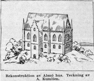
The image comes from the Swedish encyclopedia Nordisk Familjebok (edited 1923-37). The drawing of Alsnöhus, the castle of King Magnus Birgersson (known as Magnus Ladulås), also the place of signing Alsnö stadgar, should be seen as an artists impression. The remains of the building are not very extensive. In the years 1916-20, was an archaeological survey performed. They came to the conclusion that it had been a 30 meter long and 13 meter wide building. In 2 floors with a basement, built with bricks.
 BACK
BACK
©Jan Lindström 2019-2026