
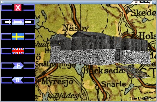

Hultaby gives you in 3D, Hultaby castle, in my view of its 14th century apperance. Today it´s a ruin, just outside the city Vetlanda, Sweden. Exists in versions for Linux,Windows and Android. You can download them from HERE.
HULTABY
Believing legends so was Hultaby castle in existents during the age of Vikings. This is not to take to seriously. The numbers of tombs from the Nordic Iron Age and also rune-stones, located in the area, may have influenced such stories. Hultaby castle, or Hultaboda ö (medieval name), is today a ruin just outside Vetlanda (Småland,Sweden). By natural land elevation and by human activity to gain land for farming, are the location no longer anything like an island (ö=island). The construction started as believed in the latter part of 13th century. It was probably burnt down during the troubled times in the 1360-s. Then was the possessor taking sides in the struggle of the Swedish crown. A accidental fire are of course also possible, who really can say? To be noticed is that little archaeological material point to people living there. 14th century was the days for most of the medieval castles in Småland. The next century was clearly fewer there. Today often designated as a slott (German schloß) Which may have been otherwise in medieval days. Hus (house) was rather common in those days, or maybe just Hultaboda.
Anyhow is the main building, placed on a by area 30x28 meter large plateau. This is made around a natural rock. The walls are mostly build without mortar. Some parts have though later been reinforced. This between the gates, and around the cellar of the tower. The building with walls of 4-5 meters where not the only one existing. Around it was about 20 houses located. Made of wood, and used as working shops, and as living areas during periods.
Hultaby should not be compared with strongholds run by kings, or by feudal lords in other places of Europe. Feudalism never really got the grip of Sweden. This was a private residence, located quite a distance to closest town. And as today surrounded by deep forrests and many lakes. But it should be noted that Erengisle Sunessons position in society, was about as high you could get in those days.
SUNESSON
The name associated with this place is Erengisle Sunesson. His father was Sune Jonsson, from who he propably inherited Hultaby. He was a knight from 1344, and a member of the kings council in 1350. When King Magnus Eriksson went to Namur (todays Belgium) as a suitor, Erengisle companioned him. The result was Queen Blanche. In an old Swedish string is she known as Blanka. Which quite possible can be what common people called here.
When Erik the son of king Magnus Eriksson became a rebellion, had he Erengisles support. Erik died though at 20. Erengisle had to go into exile, and took part in trying to get Albrekt of Mecklenburg as king. He later changed side, and fought against Albrekt. In this period was probably Hultaby burnt down. Around 1370 it ended with a conciliation, but Erengisle took part in the council that limited king Albrekts authority in 1371.
Through his second wife, the Norwegian Annot, got he also a position in the Norwegian council. Here father Malise, used the title Jarl of the Orkney Islands. Erengilse inherited this in 1353. He have though no real influence over the territory. He was probably never there. Erengrisle died in 1392. He was layed to rest in the Vadstena monastery. Hultaby was mentioned in his will. Which point at some value after all. Almost 30 years have then past since the fire at Hultaboda ö.
RENDERING
This is my view of Hultaby in its best days. It´s hardly an exact description. I am no expert in the field, only with some interest in older days. On the other hand, will you find nobody now living that in detail can describe this structure. So take it for what it is, a somewhat careful guess.
When the restauration of the castle started in the 1930-s, was the walls in pretty bad condition. The basic shape should though be clear. The relative high tower that have been imagined, should have needed a large base. Any sign of such is missing. Unintended if the remainings of today was a well (not very likely), or a cellar to a tower, or something else, so would it probably had a cover. As an compromise, have I made a lower round (eight-sided) building. The main house was in 3 joint sections. I have chosen to gradually made them lower. The stair in the end is my idea. Several entrances would have been logical. If the gates have been covered with arches of wood are
uncertain. Many nails have anyhow been found at the minor one. One last question is the existence of any wooden palisade. If not was the edge ontop the wall, probably only about 0.5 meter high. Anyhow, Hultaby was never any stronghold for maximum protection.
![]()

1693 came regementkvartermästaren (old sort of officers rank) Petter Rudebäck and surveyor Jonas Duuker to Vetlanda. They had been send by county governor Erik Dahlberg, to find and register the local ancient monuments. This for the book Suecia Antiqua Et Hodierna, which was to glorify Swedens past and then present. The most interesting for them in Vetlandas neighborhood, was the tall tales about the long gone city of Vitala. In the stories could someone just dig one and a half kvarter (22 cm) into the soil, and then find remains of paved streets and basements. Belive it if you want.
Jonas Duuker made a drawing in form of a map over Vetlanda. This was engraved as copperplate in 1709. In this case is the most interesting that Hultaby is present (1). Lacus is lake in Latin. Insula is peninsula. Not very hard to translate into English. Hellinge lacus is today named Norrsjön and Hultaby lacus is Grumlan. The peninsula were Hultaby is located was then Insula Hultabyensis. This map was made about 330 years after the buildings was burnt down, so the natural elevation of land had probably already changed the scene. You can though see that the area towards Vetlanda (right) is waterlogged.
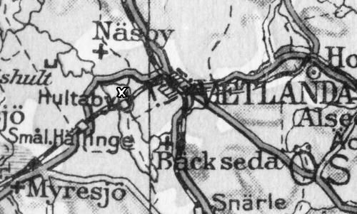
In the Swedish encyclopedia Nordisk Familjebok, edited 1923-37, is a map over Småland included. Here cut to just the area around Hultaby (the white x). The railroad is now passing by, as it has since 1885. The modern road west from Vetlanda has yet to be built. You needed then to take the trip around the Norrsjön.

And this is the changes into more recent times. The new road goes close by Hultaby. The trains has not been running for many years. The embankment though now used by bicycles and pedestrians. Land elevation, and during the 19th century regulations of water levels, has made the land dryer. Some places on the map are still marked as marsh. If Hultaby was located on an island or peninsula, when it was built, is for me an open question.

The image above shows the Emån river running just outside Vetlanda. It comes from the earlier mentioned Nordisk Familjebok. The name is here spelled with double m. Which in a way can be right, as it agree with the local pronunciation.
The surroundings of Vetlanda includes a number of grave fields. Mostly from the latter part of the Nordic Iron age. But also some from the Bronze age. The grave fields of Byestad, ranks as the biggest in Småland. It is located close by the Emån river. Probably could people by boat, travel all the way to and from the Baltic see. It is likely that the inland of Småland early on was populated from that direction, at least to some extent. The woods was deep and the terrain rough. Many watercourses may also have been cumbersome to pass. In the days of Hultaby, which not extremely back in time (13th-14th century), was there probably anyhow "roads" not far away. One should have connected the West and East hundred, that together was Njudung. Vetlanda was some sort of junction, and a place for fairs.

©Jan Lindström 2017-2026